
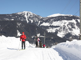
This trail is not difficult
The Village Trail is the same as the Fairy Tale Trail at the start. Where you reach the turn for the Gosaubach Bridge, keep right. Pass the Vitalhotel Gosau and continue towards Mittertal, keeping to the right of the stream. Pass the Gosauerhof Inn. In Mittertal you cross the stream and return to the Sports Centre with the road on your right. Cross the main road. There now follows a rapid descent along the Lake Gosau road. When you reach the Hotel Sommerhof, cross the main road and the stream.
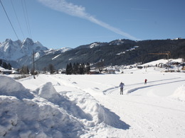
We now follow the trail along the right hand side of the Gosau stream until we reach the former Gasthof Gamsjäger. Continue a little way until we reach a fork in the trail. Bear left here, cross the bridge and then cross the main road. The route continues along the other side of the road and alternates between gentle uphill and downhill sections towards Hintertal. We return via the main road, remaining at first on the right hand bank of the river. Just before we reach the Hornspitz ski lifts, we cross to the other side of the river. Continue past the large car park for the ski lift and a few houses. At the end of a long, straight section the trail crosses, for the last time, to the other side of the stream. Keep straight on for the Sports Centre.
Download the Gosau Crosscountry trail map here...
Experience a 360° panorama tour through Gosau valley…
December to March, depending on the snow conditions
by car
from Salzburg:
Motorway exit Golling via B162 Abtenau and B166 to Gosau
from Linz:
Motorway exit Regau on Salzkammergut street B145 towards Gmunden and Bad Ischl to Bad Goisern, in Bad Goisern turn right onto B166, at the Gosaumühle junction turn right towards Gosau
from Vienna/Graz:
Motorway exit Liezen on the B320, in Trautenfels turn on Salzkammergut street B145 to Bad Aussee, turn on Koppen street through Obertraun and Hallstatt, at the Gosaumühle junction turn left towards Gosau
from Villach:
Tauern motorway to exit “Eben im Pongau”, via the B166 Pass Gschütt federal road to Gosau
by train
Attnang-Puchheim - Steinach-Irdning lines
Arrival by train in "Steeg / Gosau" then continue with bus 541/542 in the direction Gosausee
By bus
Bus 470 (Abtenau - Gosau) direction Gosau, stop Gosau Abzw. Pass Gschütt
Bus 541/542 (Bad Ischl - Gosausee) direction Gosausee, stops Haltestelle: Gosau Klaushof, Gosau Bärnausiedlung, Gosau Ressenbachweg, Gosau Vordertal B166, Gosau Ramsau B166, Gosau, Gemeindeamt, Abzw. Pass Gschütt
Detailed information on the respective train and bus times can be found at https://www.oebb.at/en/ (train) and https://www.postbus.at/en(bus).
Price according to the notice board
The cross-country ski trails in Gosau can be used free of charge. There is a charge for the parking spaces at the sports centre, recyclables collection center and castle park.
Please get in touch for more information.
Please let us know how we can improve the quality of this property or if there is any incorrect information on this page (eg. opening hours, contact, etc.).
Please fill in all fields marked *.


")