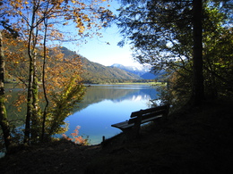
Circular route "Hamoosau - Hintersee"


- pets allowed
- Flatly
- Possible accommodation
Interactive elevation profile
Create PDF
Tour-Details
Paths covering:
hiking rout nr. 46
Länge: 11 km
Höhendifferenz: 100m
Information and hiking map you'll get at the Tourism Office
further information:
- Flatly
- Possible accommodation
- Board possible
Details - hiking
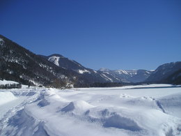
- cleared winter hiking path
daily accessible
")
By car:
Arrival via the West motorway A1, junction Thalgau.
Follow the main road (B 158) in direction to Hof bei Salzburg until you reach the traffic circle “Baderluck”. At the first junction turn into the main road (Hinterseestraße) and after a few kilometers you reach your holiday destination Faistenau.
There are plenty of parking areas near the starting points.
With the Postbus
From Salzburgs bus station, opposite the train station, there is a good bus connection into the
Fuschlsee region and also to Faistenau. You will find details in internet under www.svv-info.at.
With the Train
Information and connections can be found under following addresses www.oebb.at or www.bahn.de
By Air
Salzburg Airport lies very close to Salzburg city. The Bus Nr. 2 brings you from the airport to the main station where you change to continue with the post bus.
no parking fees
- Suitable for groups
- Suitable for schools
- Pets allowed
- Spring
- Summer
- Autumn
Please get in touch for more information.
Am Lindenplatz 1
5324 Faistenau
Phone +43 6226 8384 - 41
E-Mail faistenau@fuschlseeregion.com
Web www.fuschlseeregion.com
Web www.faistenau.at
http://www.faistenau.at
You can also visit us on
Visit us on FacebookInteractive elevation profile
Create PDF
Tour-Details
Paths covering:
Circular route "Hamoosau - Hintersee"
Suggest changes
Please let us know how we can improve the quality of this property or if there is any incorrect information on this page (eg. opening hours, contact, etc.).
Please fill in all fields marked *.