Real moments.
#Salzkammergut
Kreuzstein - Eisenau Alp - Schafberg


Interactive elevation profile
Create PDF
Tour-Details
Paths covering:
Description: An early onset of winter in September 2024 caused countless trees to fall across the hiking trail between Eisenau and Suissensee. The path is passable with severe restrictions. It is currently not possible for volunteers to repair the forest damage in this inaccessible area due to the danger to life. A solution to the problem is being worked on.
One of many ways to conquer the Schafberg!
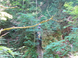
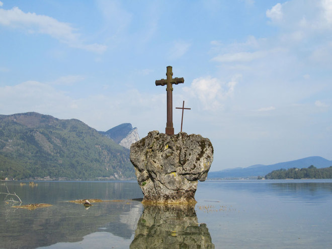
Caution - alpine experience required from Eisenau-Alm!We park at the car park of the public state bathing area. In the water we see a stone with two crosses after which the area here is named "Kreuzstein" . From there, the trail climbs steeply into the forest, where the Waterfall Kreuzstein awaits us as the first highlight after 10 minutes. Continuing up through the forest over several streams and a spectacular bridge construction with well-secured ladders, we reach a hunting lodge with a fantastic view over Lake Mondsee. From here, it ...
further information:
- Board possible
Direction information: Departure


")
")
")
")
")
")
")


From Salzburg via the A1 - Mondsee exit
From Vienna/Linz via the A1 - St. Georgen exit, Attersee via Nußdorf to Unterach
From the west - Bad Ischl-Weißenbach-Unterach
Train:
From Salzburg or Linz/Vienna to Vöcklamarkt. Linz/Vienna to Vöcklamarkt, continue with the Attergau Bahn to Attersee, continue by bus to Unterach
Airplane:
From Salzburg via the A1 - Mondsee exit
From Vienna/Linz via the A1 - St. Georgen exit
- Spring
- Summer
Please get in touch for more information.
Dr. Franz Müller Straße 3
5310 Mondsee am Mondsee
Phone +43 6232 2270
Fax machine +43 6232 2270
E-Mail info@mondsee.at
Web mondsee.salzkammergut.at
Web attersee-attergau.salzkammergut.at
https://attersee-attergau.salzkammergut.at
You can also visit us on
Visit us on Facebook Visit us on Instagram Visit us on Pinterest Visit our videochannel on YouTube WikipediaInteractive elevation profile
Create PDF
Tour-Details
Paths covering:
Kreuzstein - Eisenau Alp - Schafberg
Suggest changes
Please let us know how we can improve the quality of this property or if there is any incorrect information on this page (eg. opening hours, contact, etc.).
Please fill in all fields marked *.