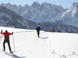
Gosau Fairy Tale Trail

- Suitable for families
- Flatly
Interactive elevation profile
Create PDF
Tour and route information
Paths covering:
Technically an easy trail
The start of the Fairy Tale Trail is flat as you pass through the fields parallel to the Gosau stream, heading for Mittertal. After approx. one kilometre you will reach a fork. Bear right over the bridge, continue straight on, and after a short ascent you will enter the woods. The route continues through romantic woodland and open meadow land until you reach Vordertal. You now follow a loop which leads you back to the Gosau stream. Follow the stream back to the Sports Centre.
Download the cross-country trail plan for Gosau
Experience a 360° panorama tour through Gosau valley…


further information:
- Flatly
Details - Trail
- Nordic skiing facilities: Marked Nordic skiing run
- Type of Nordic skiing run: Classic + skating
- free
Altitude profile
December to March, depending on the amount of snow
by car
from Salzburg:
Motorway exit Golling via B162 Abtenau and B166 to Gosau
from Linz:
Motorway exit Regau on Salzkammergut street B145 towards Gmunden and Bad Ischl to Bad Goisern, in Bad Goisern turn right onto B166, at the Gosaumühle junction turn right towards Gosau
from Vienna/Graz:
Motorway exit Liezen on the B320, in Trautenfels turn on Salzkammergut street B145 to Bad Aussee, turn on Koppen street through Obertraun and Hallstatt, at the Gosaumühle junction turn left towards Gosau
from Villach:
Tauern motorway to exit “Eben im Pongau”, via the B166 Pass Gschütt federal road to Gosau
by train
Attnang-Puchheim - Steinach-Irdning lines
Arrival by train in "Steeg / Gosau" then continue with bus 541/542 in the direction Gosausee
By bus
Bus 470 (Abtenau - Gosau) direction Gosau, stop Gosau Abzw. Pass Gschütt
Bus 541/542 (Bad Ischl - Gosausee) direction Gosausee, stops Haltestelle: Gosau Klaushof, Gosau Bärnausiedlung, Gosau Ressenbachweg, Gosau Vordertal B166, Gosau Ramsau B166, Gosau, Gemeindeamt, Abzw. Pass Gschütt,
Detailed information on the respective train and bus times can be found at https://www.oebb.at/en/ (train) and https://www.postbus.at/en(bus).
Parking
- Parking space: 30
- Bus parking space: 5
Price according to the notice board
The cross-country ski trails in Gosau can be used free of charge. There is a charge for the parking spaces at the sports centre, recyclables collection center and castle park.
- Free entry
- Suitable for groups
- Suitable for schools
- Suitable for teenagers
- Suitable for seniors
- Suitable for single travelers
- Suitable for families
- Suitable for friends
- Suitable for couples
- Suitable for children
- Early winter
- Deep winter
Please get in touch for more information.
")
")
Interactive elevation profile
Create PDF
Tour and route information
Paths covering:
Gosau Fairy Tale Trail
Suggest changes
Please let us know how we can improve the quality of this property or if there is any incorrect information on this page (eg. opening hours, contact, etc.).
Please fill in all fields marked *.


